Mines & Earth Sciences
81 Creation of Landslide Database in Iceland Assessing Mechanisms, Occurrences, and Hazards
Claire Cruz and Leif Anderson (Geology and Geophysics)
Faculty Mentor: Leif Anderson (Department of Geology)
Abstract
A landslide is the movement of rock, debris, or earth down a slope. Landslides are serious geological hazards often triggered by tectonics, glaciation, and erosion. This research identifies the locations and parameters of landslides in Iceland by creating the first comprehensive landslide database of Iceland. Iceland has few trees making it easy to identify the landslides, and the rock type is almost entirely basaltic (with some rhyolite) making it easier to track trends. Iceland was completely covered by ice during the last age and glaciers helped form the steep fjord topography near the coasts. coasts.
Introduction
Iceland is characterized by its tectonic activity and periods of glaciation. These geologic processes have resulted in a diverse range of landscapes, including mountains, glaciers, volcanoes, and fjords. However, these geological features also make Iceland prone to natural hazards such as landslides. Landslides are a significant threat to the infrastructure, economy, and environment of Iceland. Understanding causes and impacts of landslides is crucial for developing effective strategies for hazard mitigation and disaster management.
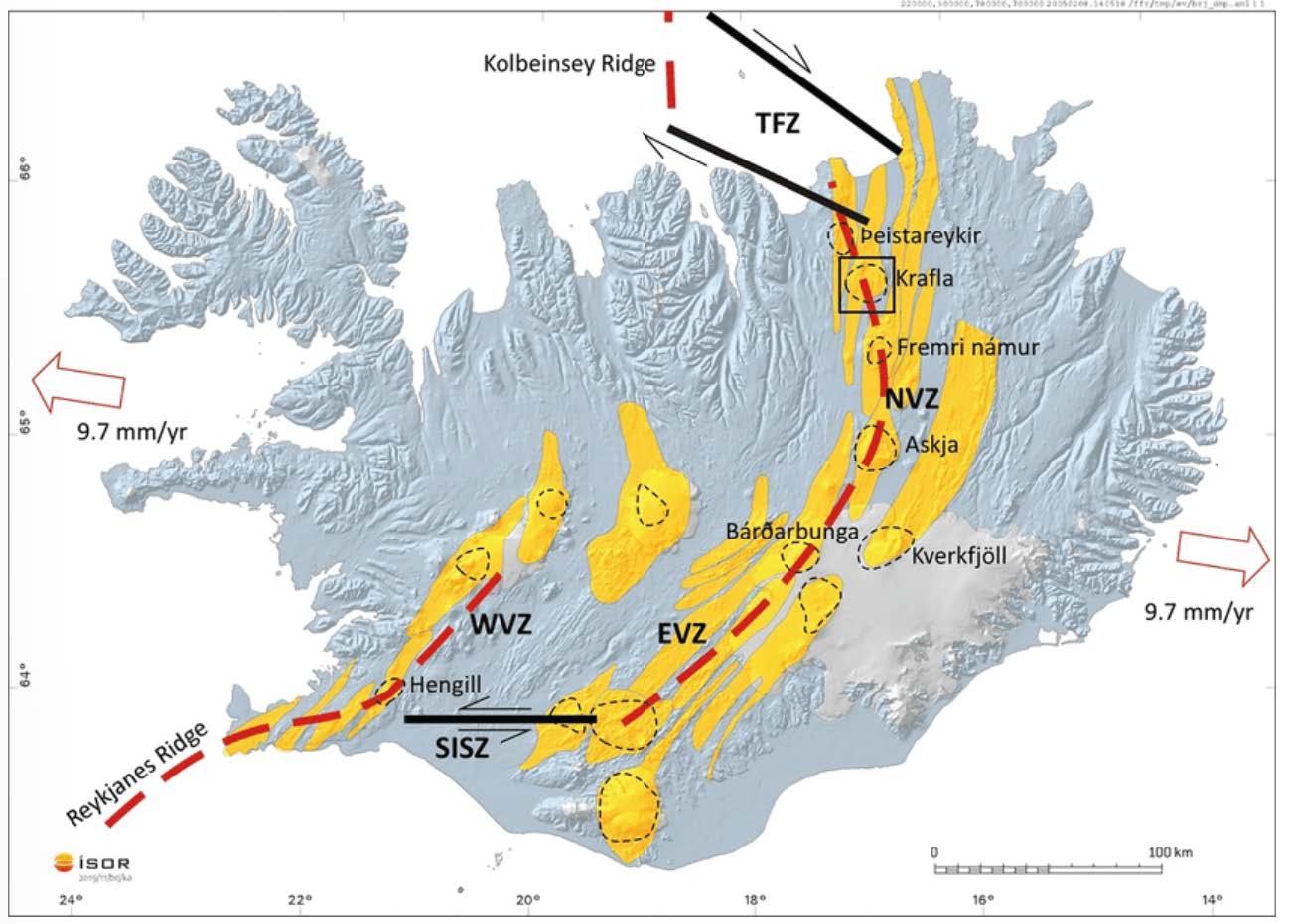
Figure 1: Tectonic map of Iceland. A Mid Ocean Ridge divides Iceland and is an active spreading center. Yellow-colored regions around the MOR indicate active volcanic regions and central volcanos are outlined in black. Iceland is spreading at a rate of 9.7mm/yr.
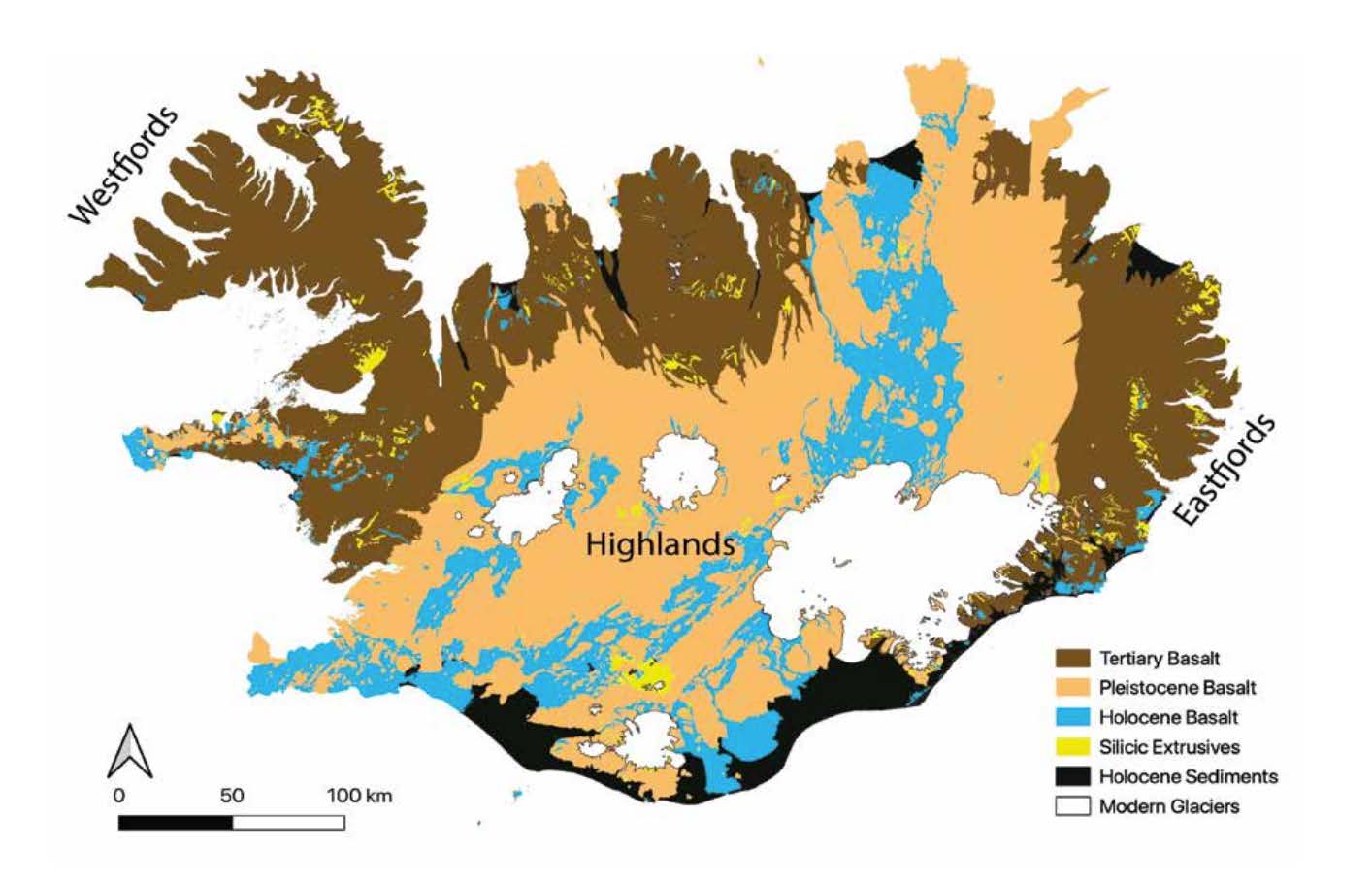
Figure 2: Geologic Map of Iceland. The rock age increases from the spreading center [MOR described in Figure 1]. The youngest topography is modern glaciers and the oldest is tertiary basalt. Silicic intrusions appear to speak sporadically around Iceland and indicate the presence of former central volcanos that are composed of weak montmorillonite or rhyolitic clay.
Methods
We used aerial and satellite imagery from Google Earth and Landmælinga Íslands Geodesy of Iceland. Hummocky tomography and abrupt topography changes often indicate the presence of a landslide. In Google Earth, we have digitized just over 2,000 landslides and run analyses on the collected data using Python and ArcGIS. In addition, we have created a series of plots to present findings.
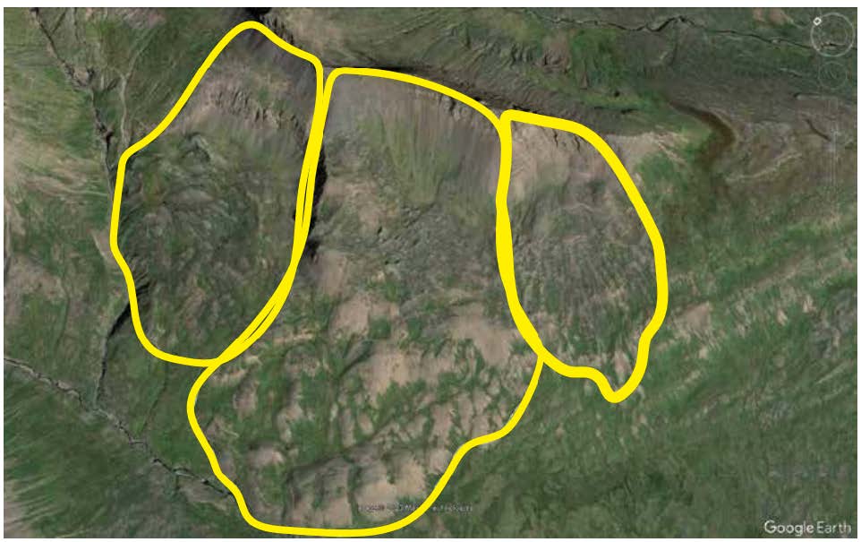
Figure 3: Example of 3 landslides outlined in Google Earth
Results and Discussion
Much of Iceland’s topography is composed of fjords which are long, narrow, deep inlets formed by the erosion of valleys and mountains by glaciers. The process of fjord formation began during the last Ice Age, approximately 18,000 years ago. As the glacier moves, it erodes the bedrock beneath it, creating U-shaped valleys. Over time these U-shaped valleys erode and create steep V-shaped valleys that are weak and highly susceptible to landslides. In Iceland, these fjords are concentrated in the northern, eastern, and western regions, and our findings indicate that most of the landslides are concentrated in these areas with some exceptions being landslides around former central volcanos or areas of particularly steep topography. Tectonics also plays a large role in Iceland’s landscape. The MOR that runs through Iceland serves as a spreading center and an active site for volcanism. Central volcanos form along the MOR and propagate outward eroding over time and becoming over steepened hillslopes subject to failure. Topography near the MOR is shallow dipping and dips increase as you move farther from the spreading center.
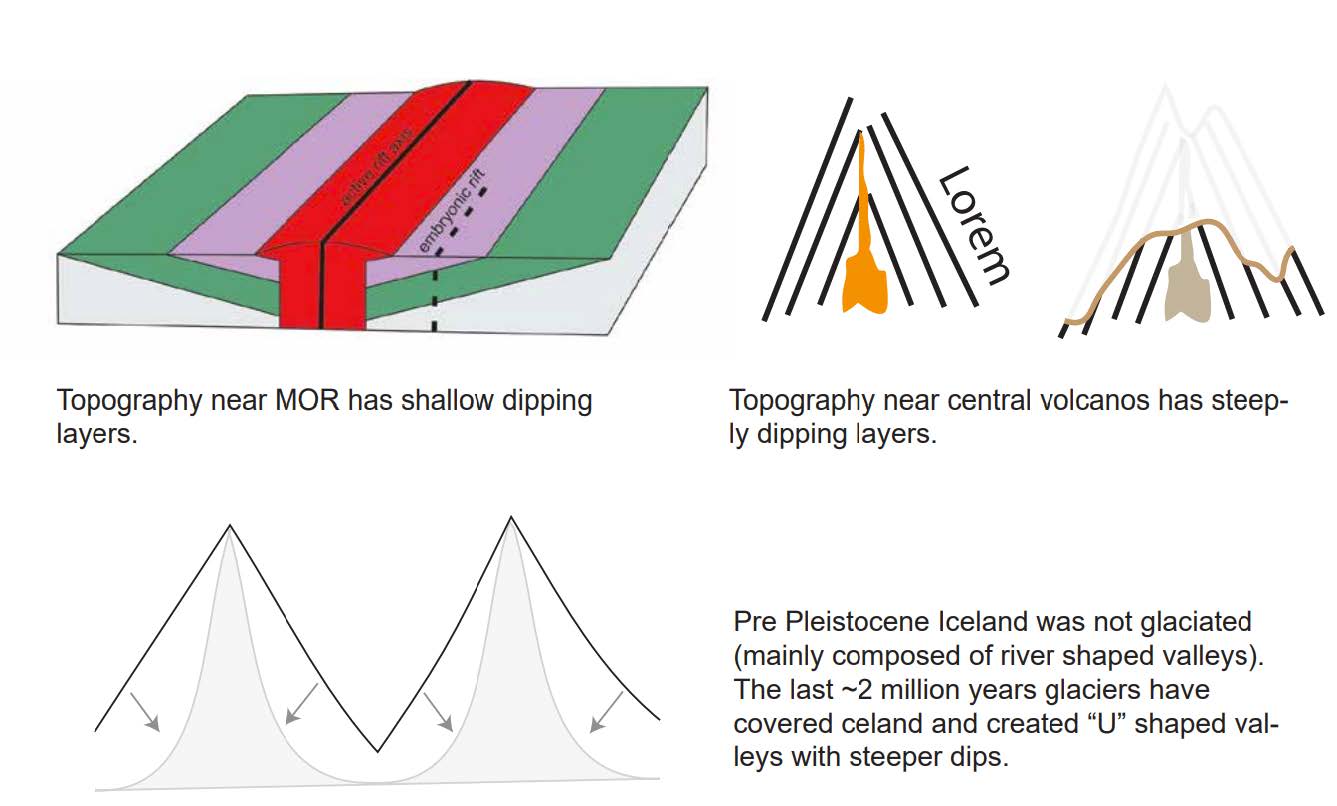
Figure 4: Different topography and steepness of hillslopes.
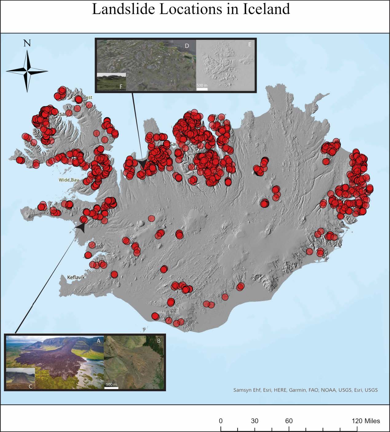
Figure 5: Red dots represent individual landslide locations we have identified. Images A-F are photos of landslides at specific locations.
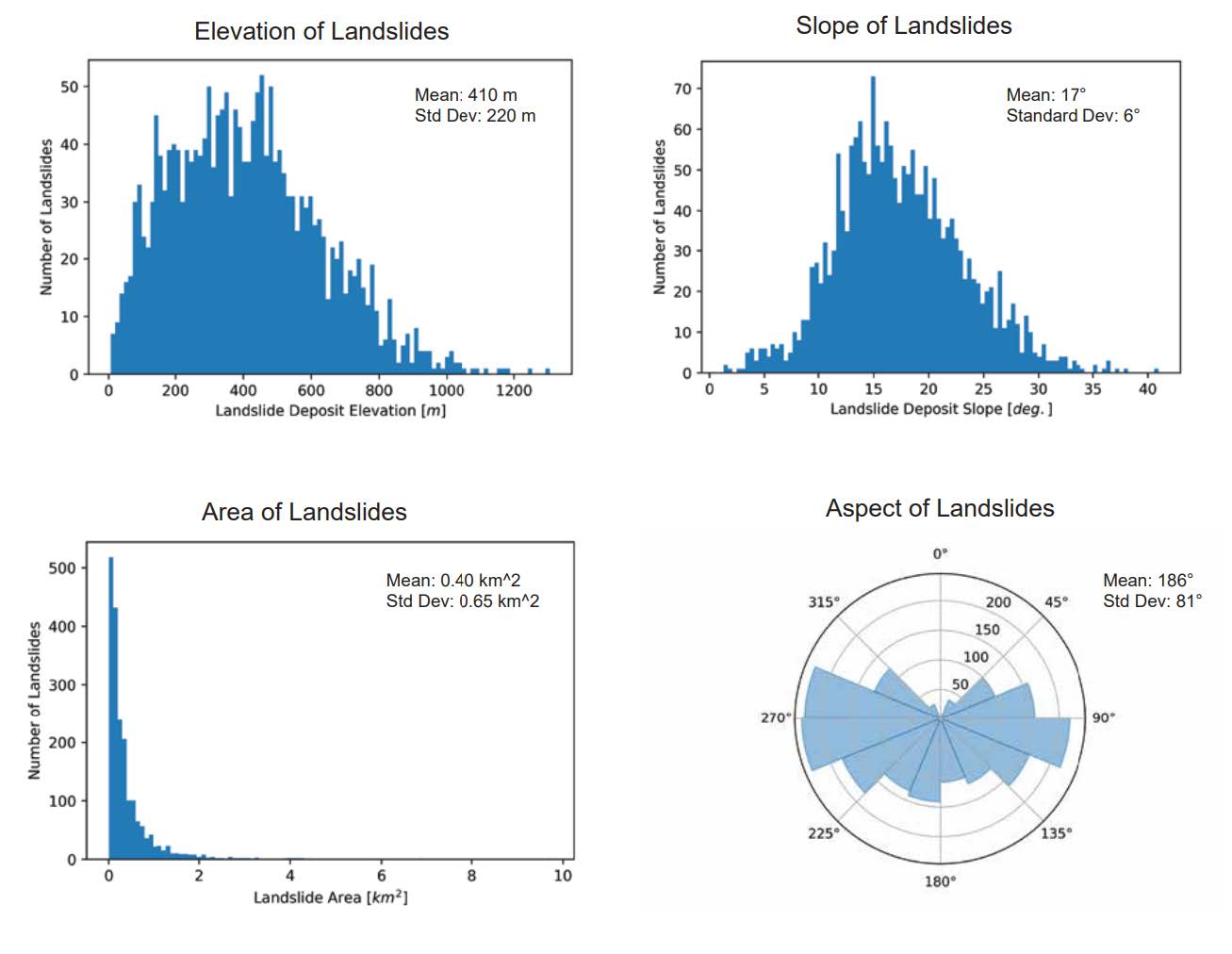
Figure 6: We created plots of Elevation, slope, area, and Aspect. We calculated the mean elevation as 410m with a standard deviation of 220, mean slope as 17 degrees with a standard deviation of 6 degrees, mean area as .04 square Km with a standard deviation of .65 square Km, mean aspect as 186 degrees with a standard deviation of 81 degrees.
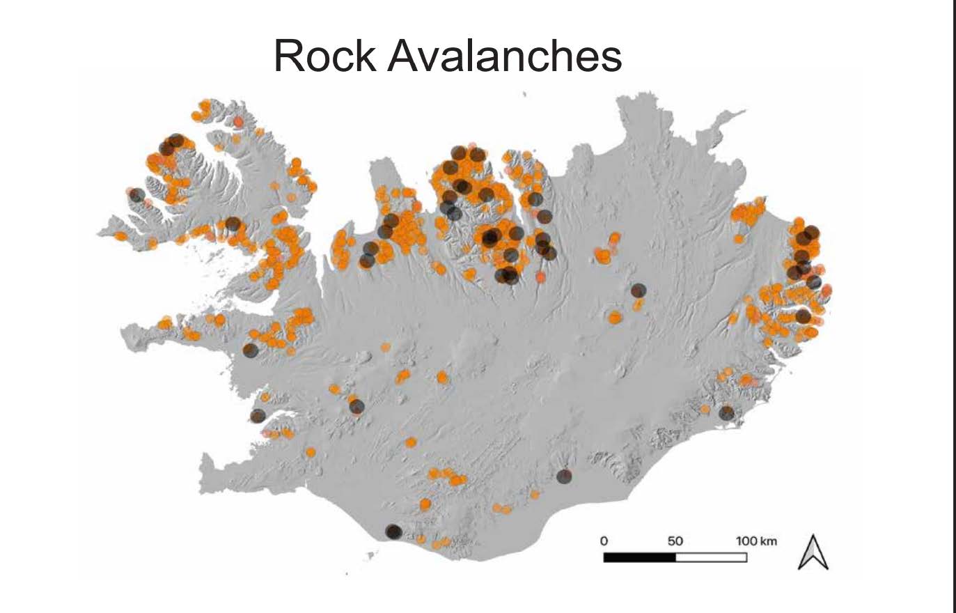
Figure 7: Orange dots represent landslide locations and black dots indicate rock avalanches. Rock avalanches are landslides with > 1 million cubic meters of mass moved.
Future Work
We have identified a little over 2,000 landslides in Iceland, however, Iceland’s landscape is constantly changing. We plan to continue updating the database and update run new analyses.
References
Bell, R., and T. Glade. “Multi-hazard analysis in natural risk assessments.” Landslides 1 (2012): 1-10.
Evans, S. G. “Landslides.” Bulletin of the Geological Survey of Canada 548 (2001): 43-79.
Guangrun, L. I. U., Y. A. N. Echuan, and L. I. A. N. Cao. “Discussion on classification of landslides.”地质学报10.4 (2002): 339-342.
Highland, Lynn, and Peter T. Bobrowsky. The landslide handbook: a guide to understanding landslides. Reston: US Geological Survey, 2008.
Jakob, Matthias. “Landslides in a Changing Climate.” Landslide Hazards, Risks, and Disasters, 2022, pp. 505–579.
Jakobsson, Sveinn P., Kristján Jónasson, and Ingvar A. Sigurdsson. “The three igneous rock series of Iceland.” Jökull 58 (2008): 117-138.
Keefer, David K. “Rock avalanches caused by earthquakes: source characteristics.” Science 223.4642 (1984): 1288-1290.
Malamud, Bruce D., et al. “Landslides, earthquakes, and erosion.” Earth and Planetary Science Letters 229.1-2 (2004): 45-59.
Melosh, H. Jay. “The mechanics of large rock avalanches.” (1987).
Nagler, T., et al. “Analysis of Landslides in Alpine Areas by Means of SAR Interferometry.” IEEE International Geoscience and Remote Sensing Symposium.
NAKAMURA, Hiroyuki, and Satoshi TSUCHIYA. “Analysis on Piles for Landslide Control under Consideration to Displacement of Sliding Mass.” Landslides, vol. 24, no. 2, 1987.
Nicoletti, Pier Giorgio, and Marino Sorriso-Valvo. “Geomorphic controls of the shape and mobility of rock avalanches.” Geological Society of America Bulletin 103.10 (1991): 1365-1373.
Saemundsson, Th, Halldór G. Pétursson, and Armelle Decaulne. “Triggering factors for rapid mass movements in Iceland.” Debris-Flow Hazards Mitigation: Mechanics, Prediction, and Assessment 1 (2003): 167-178.
WIECZOREK, G. F. (1984). Preparing a detailed landslide-inventory map for Hazard Evaluation and reduction. Environmental & Engineering Geoscience, xxi(3), 337–342.
Wong, H. N., K. K. S. Ho, and Y. C. Chan. “Assessment of consequence of landslides.” Landslide risk assessment (1997): 111-149.
Van Den Eeckhaut, M., & Hervás, J. (2012). State of the art of National Landslide databases in Europe and their potential for assessing landslide susceptibility, Hazard and risk. Geomorphology, 139-140, 545–558.
