Nubia: The Kingdoms of Kerma and Kush
The Kingdom of Kush Explained in 10 minutes
Nubia: The Kingdoms of Kerma and Kush

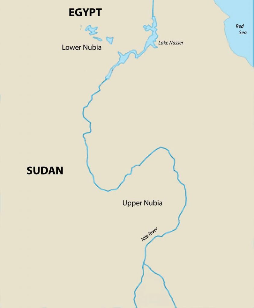
The region south of Aswan, at the first cataract of the Nile River, is commonly called Nubia. Nubia is notable for its long-term, dynamic relationship with ancient Egypt. Just as importantly, Nubia was also the site of an early civilization. The kingdoms of Kerma (c. 2400 BCE to 1500 BCE) and Kush (c. 1000 BCE to 300 CE) emerged along the Nile River. These kingdoms prospered especially due to their productive agriculture and the region’s copious natural resources. At certain points, both Kerma and Kush were strong enough to successfully invade Egypt. These kingdoms in Nubia also developed their own religious and cultural traditions, including a written script, Meroitic. While the people of this region, known collectively as Nubians, borrowed heavily from the Egyptians, Nubians also had distinctive practices that set their civilization apart from that of their northern neighbors.
Scholars generally link the origins of ancient Kerma (in present-day Sudan) back to the desiccation of the Sahara Desert and the rise of dynastic Egypt. Similarly to ancient Egypt, the drying out of the region encouraged people to move closer to the Nile River in the years between 5,000 and 4,000 BCE. Rock paintings, showing cattle in areas that have been desert for thousands of years, attest to the environmental changes in Nubia and also the development of a cattle culture that dates back to at least the fourth millennium BCE. Just as in Egypt, the desiccation of the Sahara desert drew together people from all directions. As people settled closer to the Nile River in Nubia, they brought their cattle, their agricultural traditions, and their languages, building settlements with higher population densities.
Additionally, Egyptian elites desired ivory, animal skins, incense, and other luxury goods prompting trade between Nubia and Egypt that pre-dated the unification of Egypt. With increased demand for luxury goods as social stratification grew, the Egyptians even ran military forays into Nubia. After unification, the Egyptians continued to invade Nubia to trade and raid for slaves and cattle. Likely,
Nubian desires to control trade and protect themselves from Egyptian raids further compelled state formation in Nubia. Without Nubian records from the third millennium BCE, it is difficult to identify additional reasons why the state arose. However, archeological evidence does clearly indicate that by about 2400 BCE, Nubians had formed the Kingdom of Kerma between the third and fourth cataracts of the Nile River.
Kerma (c. 2400 BCE to c. 1500 BCE)
Kerma endured in Upper Nubia for almost a thousand years. The kingdom is named after its capital city at Kerma at the third cataract, but excavations at other sites (where similar pottery styles and burial sites have been found) suggest that at its height Kerma’s reach may have extended more than 200 miles southward past the fifth cataract of the Nile River. So far, archaeological evidence indicates that, with the exception of the capital and perhaps one or two other cities, most of the people in Kerma lived in smaller villages. They grew crops like barley, and kept goats, sheep, and cattle, sending tribute to their capital. The people of Kerma also developed industries, especially in mining, metalworking, and pottery. Kerma was linked inter- regionally through trade to its tributary villages, to dynastic Egypt, and to sub-Saharan Africa. Egyptian pharaohs and elites wanted the gold, copper, slaves, ivory, exotic animals, and more that they obtained from Kerma.
The people of Kerma also made use of their location on the Nile and proximity to Egypt as they imported textiles, jewelry, and other manufactured goods. Presumably, one reason that Nubian leaders built their ancient capital at Kerma was to oversee river trade. At the impassable cataract, boat owners unloaded their cargo and took it overland past the shallows and rocks before again proceeding on the water. This location at the cataract gave the leaders at Kerma the chance to tax, divert, and register goods being transported between Kerma and Egypt.

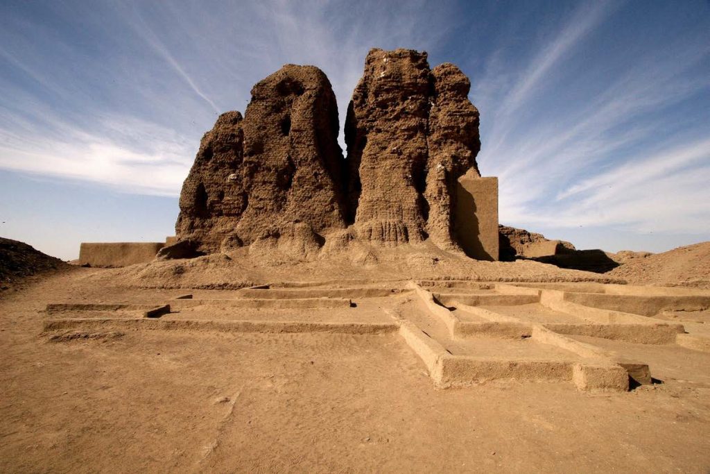
Agricultural surpluses and other tributary payments supported the rulers and elites of the capital. Archaeologists have shown that the capital had defenses, including ditches, ramparts, and massive walls with towers. There were also palaces within the city and on its outskirts. However, the most famous structure is the Western Deffufa (Figure 2.13) made of mud-bricks, which likely served as a temple. Two other deffufa, large mud-brick structures with spaces for rituals on top, have been at least partially excavated within the vicinity of Kerma. Another notable archaeological find is the Eastern Cemetery, which lies a couple of miles to the east of the city. It served as the burial site for Kerma’s rulers for almost a thousand years and contains over 30,000 tombs. Some of the tombs were covered with large mounds. Demonstrating the cattle culture of the region, dozens of cattle skulls encircle a number of the tombs. Tombs also contain the remains of human sacrifices and other symbols of wealth and status, like jewelry made of gold and silver. The largest tomb found to date is 300 feet in diameter and covered with black granite, white quartz pebbles, and a marble top. Its interior burial suite contains semi-precious stones, bronze weapons, and lavish furniture. In the corridor leading into the underground burial site, archaeologists unearthed the remains of horses, dogs, and about 400 human sacrificial victims. The cattle skulls, mounds, and the remains of human sacrifices have led scholars to suggest that the Kerma elite had their own styles for monumental structures like the Western Deffufa and their tombs, even though they sometimes employed Egyptian artisans to complete the construction of these grand projects.
It appears that Kerma was strongest when neighboring Egypt was weak. As a case in point, during Egypt’s Second Intermediate Period, Kerma, at the height of its power, successfully invaded parts of Upper Egypt and established diplomatic relations with the occupying Hyksos. Once reunified during the New Kingdom, Egypt retaliated by conquering Kerma to the fourth cataract. Then, Egypt occupied Kerma for the next 500 years. During the Egyptian occupation, the elite classes of Kerma adopted many elements of Egyptian culture, including Egyptian gods, styles of dress, Hieroglyphics, and the Egyptian language. However, scholars believe that the Nubian masses retained their own distinctive identity with their local language and customs.
The Kingdom of Kush
As Egypt entered its Third Intermediate Period, Nubians gradually established their independence, eventually creating a new state, the Kingdom of Kush in the eighth century BCE. The initial capital of the Kingdom of Kush was Napata (c. 750 BCE to 593 BCE). From Napata, the Nubians took control of Upper Egypt, establishing the “Ethiopian Dynasty,” which ruled for 60 years from Thebes. Assyrian invasions destabilized the Nubian rulers in Thebes, causing the last pharaoh of the Ethiopian Dynasty to flee to Napata. Then, once strengthened, the Egyptians pushed back. The Egyptian army sacked Napata in 593 BCE and, in response, the Nubian rulers moved their capital farther south to Meroe. (See Map 2.9.) At this southern location, they further developed their civilization, which lasted until the fourth century CE.

With the new capital at Meroe, a location with well-watered farmland and some distance between it and Egypt, the Kingdom of Kush flourished. Meroe got more rainfall than Napata and was not as dependent on the Nile floods. Nubians were able to extend the areas under cultivation and grow a wider variety of crops, like cotton, sorghum, and millet. They were also able to easily graze their livestock and, as a result, during this period cattle became even more important as a symbol of their culture and wealth.
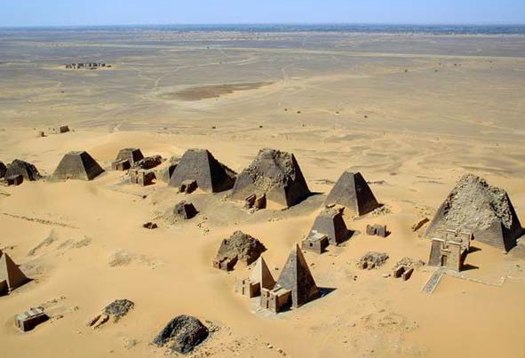
After moving the capital to Meroe, the culture of Kush showed more independence from Egypt as well. Particularly as Egypt’s power declined, the people of Kush put more emphasis on their own deities and pushed Egyptian gods to the background. For example, temples devoted to a Nubian war god, Apedamak, “the Lion of the South,” received more support and even used live lions for rituals. Gold had long been mined in the region and remained important while the people of Kush continued to develop additional industries. The area was rich in iron ore and the hardwoods used to make charcoal, which encouraged the growth of a booming iron industry. They made iron weapons and tools that they used for defense and to increase their crop yields. They were able to trade their agricultural surpluses, iron, cattle, and exotic things like elephants from sub-Saharan Africa, with Egypt, Greece, Rome, and India, bringing great wealth and prestige to Meroe. Also, the rulers of Meroe commissioned pyramids but had them built in a local style. As evident in Figure 2.14, their pyramids were smaller and had a unique shape. Kush burial practices were different than those used in dynastic Egypt, as corpses were not always mummified and were buried in the fetal position. Finally, a new locally-created written script, Meroitic, replaced the use of Egyptian Hieroglyphics by 300 BCE. Modern scholars have not yet translated Meroitic, and students of their culture will surely learn even more about the Kingdom of Kush once scholars have done so. As for now, we know that very productive agriculture, local rituals and burial practices, the growth of industries, social stratification facilitated by Meroe’s wealth and extensive trade networks, and the written script Meroitic, were some of the distinctive elements of the civilization at Kush.
While the Greeks and Romans occasionally sent raiding parties into Nubia, for a while, Meroe’s southern location helped isolate it from conquest. Legends also emphasize the strength of Meroe’s army and the physical prowess of its soldiers. Environmental changes, internal rivalries, and the rise of Axum (a new state to the East) likely all contributed to the fairly abrupt collapse of Meroe in the fourth century CE.
Egyptian sources were generally very derogatory in their portrayal of Nubians and even a few early twentieth century archaeologists carelessly (and incorrectly) identified these Nubian kingdoms as slave colonies of the Egyptians. However, the kingdoms of Kerma and Kush were known in the ancient world for their wealth and industries. The wealth garnered through productive agriculture and trade supported a ruling class, great artists, and monumental architecture. Egyptian culture was influential, but Nubians adapted Egyptian practices to meet their own needs and sensibilities. Often entangled with Egypt and sometimes defending themselves from other invaders as well, these two kingdoms persisted for hundreds of years, creating an independent civilization along the southern stretches of the Nile River.

