College of Social and Behavioral Science
119 Understanding Aincent Granary Distributions in the Grand Staircase Escalante National Monument
Matthew Eisenberg
Faculty Mentor: Brian Codding (Anthropology, University of Utah)
Abstract
Granaries are architectural features designed to store food. They are a recurring feature in the archaeological record of past farming communities in Utah, but their placement across the landscape range from central residential areas to remote, hard-to-reach locations. This variation raises questions about changing food storage strategies over time. This research investigates granary distribution within the Grand Staircase-Escalante National Monument (GSENM), focusing on how spatial and temporal patterns reflect shifts in defensive behavior. Drawing on new archaeological data from Fifty Mile Mountain and prior site records, this study analyzes 78 granaries using radiocarbon dating and spatial modeling. Granaries were classified as residential or remote based on a distance threshold of 120.50 meters from the nearest long-term occupation site. Using a generalized linear model with natural splines, the probability of a granary being remote over time was estimated. Results show a clear shift beginning around 1,400 calibrated years BP, when remote granaries become increasingly common. This trend suggests a movement from active defense of centralized storage near long-term occupation sites, to passive defense strategies that relied on dispersing and scattering storage in remote settings. The increased use of remote granaries likely reflects rising population pressures, increased competition for resources, and the need to mitigate resource theft. These findings provide new insight into the socioecological adaptations of prehistoric communities navigating agricultural risk and intergroup dynamics in the GSENM.
Key words: Fremont, Ancestral Puebloan, Residential Granary, Remote Granary, Passive Defense, Active Defense, Radiocarbon Dating
Introduction
The Grand Staircase Escalante National Monument (GSENM) is a desert landscape composed of sandstone canyons and rolling hills dotted with juniper and pinyon trees. Observing this arid landscape today it may be hard to believe that Indigenous families thrived in this area for the past 12,000 years (Spangler & Zweifel 2021). In truth, there has rarely been a time since humans first arrived to what today is southwestern Utah that the region was not occupied (Spangler & Zweifel 2021). The people living in this GSENM employed various subsistence strategies for survival. However, it is the arrival of agriculture about 2,000 years ago that would profoundly change how people lived and interacted with the landscape (Codding et al. 2022; Spangler & Zweifel 2021). This shift, while bringing increased food security, did not come without cost. The need to protect food for the coming year proved to be a demanding aspect of a subsistence farming lifestyle. People of the region needed a way to mitigate seasonal and inter-annual food variability, leading to the development of complex food storage structures to manage food surpluses (Winterhalder et al. 2015; Spangler & Zweifel 2021). A complex food storage strategy would manifest in the form of granaries (Figure 1), an architectural feature common in agricultural groups (Yaworsky 2021) and some foraging populations (Morgan 2012). However, it has been noted for some time in numerous archaeological surveys that granaries exhibit great variability. Gunnerson et al. (1969) comments on how some granaries are found within residential contexts while others are found several miles from long-term habitation sites, either placed on cliff edges or hidden out of sight. This variation in placement raises questions about the underlying factors influencing these differences.
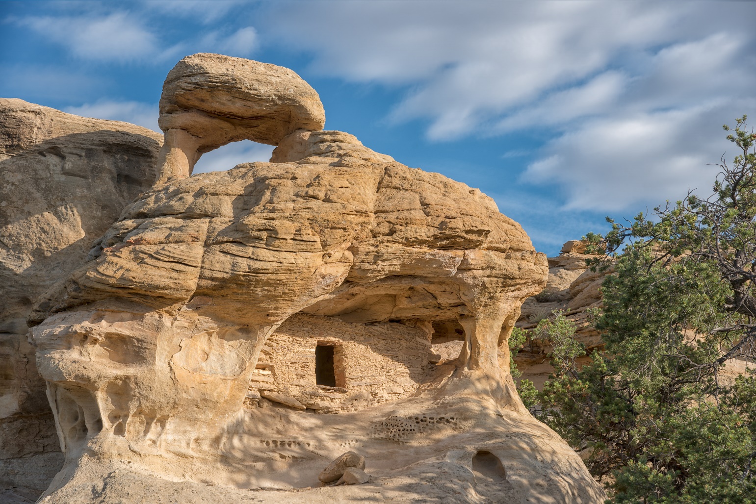
Figure 1. A granary found within the GSENM. This granary was utilized within the study Photo credit: Jerry D. Spangler (Spangler et al. 2024)
Variation in granary placement reveals interesting dynamics influencing defensive behaviors of prehistoric farmers over time. Taking into consideration what is economically viable when storing food for future use, building granaries in far, hard-to-reach places seems unreasonable due to the high costs that come with building and transporting food. Not only is accessing these structures difficult, but construction, use, and maintenance would be incredibly costly. A simple, more effective strategy would be to store agricultural surpluses centrally, either close to residential locations or near the point of production (Barlow & Phillips 2010; Yaworsky 2021). Differences in defensive behavior are one explanation brought forward to explain the variation in storage strategy. With active defense of centralized storage near residential sites and passive defense through the scattering and hiding of further granaries (McCool & Yaworsky, 2017). However, it is unlikely that these defensive strategies emerged simultaneously. It is more likely that centralized storage strategies emerged first. Then, passive defense of storage began appearing due to shifts in the suitability of farming and increases in population (Yaworsky 2021; Codding et al. 2022). Based upon this logic, early sites should prioritize central storage, and later sites should shift to passive defense as competition and environmental pressures increase over time. To evaluate this predicted shift in storage strategy, the following research investigates how granary placement varies over time, with particular attention to proximity to residential sites.
Methods
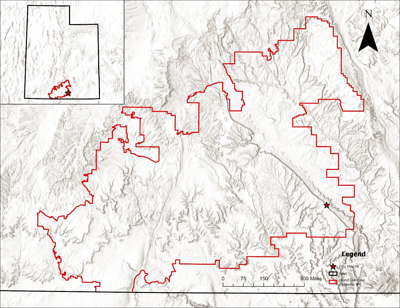
Figure 2. Map showcasing the GSENM and Fifty Mile Mountain
Data Collection
The methods used to address the prediction involved data collection, spatial analysis in ArcGIS Pro (ESRI, 2025) then building statistical models in the R environment (R Core Team 2025). Primary data collection involved conducting archaeological site visits during spring 2024, led by the Colorado Plateau Archaeological Alliance (CPAA) within the GSENM (Spangler et al. 2024). During the fieldwork, known granaries within the 50 Mile Mountain region (Figure 2) were re-visited, and then organic samples were collected from the granaries. These samples were then taken to the UUAC, where they were prepared to be radiocarbon dated. Lab work was undertaken by the author under the supervision of Ishmael Medina. The samples included wood timber, hardened mud adobe used as masonry for granary construction (see Yaworsky 2021) and maize (Zea mays) cobs left when the granaries were abandoned. We sorted all samples and subset organic material (e.g., charcoal, wood, plant fiber, and maize [Zea mays]) of the correct weight fir radiocarbon dating. Samples were then sent to International Chemical Analysis (ICA) in North Bethesda, MD for radiocarbon dating.
The next phase of data collection was measuring a granaries distance from the closest residential site. To do this, the archaeological sites visited in spring 2024 were placed into ArcGIS Pro based on their geographic coordinates (ESRI, 2025). The site’s input in ArcGIS Pro consisted of storage sites with granaries, long-term residential sites, and temporary camp locations. The site type was determined from looking through the site records from the CPAA work (n = 56)s. More granary sites were also added to the study from a report completed in 2016 by Douglas McFadden and the Bureau of Land Management; these sites also included calibrated years before present dates and locations, bringing the study size to 78 samples. The granaries, sample type, location, calibrated BP date, and distance from the nearest residential site were input into a granary database to be used for later analysis in R (R Core Team 2025).
Model Building
To test the prediction that distance from residential sites should increase over time, the probability that a granary would be remote given its occurrence temporally was modeled. The data collected represented a binomial distribution, with a granary either being remote or residential. While granaries have many contexts that can determine their type, distance was the focus of the study. So, a maximum distance threshold was determined to classify sites as being remote or residential. The maximum distance threshold was set to be 120.50 meters from a residential location, and was the greatest extent a granary could be classified as residential; granaries over this threshold would be classified as remote. The maximum distance threshold was determined by using evidence presented in site recording forms. The furthest granary that occurred with concrete evidence it was utilized in a centralized storage setting occurred at 120.30 meters.
Statistical models were built in R (R Core Team 2025) to find the probability that a granary is remote or residential based on distance and temporal context. To model this probability, a generalized linear model (GLM) was used. A GLM is a family of models that estimate unknown parameters to best fit a set of observations (Codding & Brewer, 2024). In this case, the unknown parameter of the model was the probability that a granary will be remote in a given time. The relationship of the model was not expected to be linear, so natural splines were incorporated into the model to allow for non-linear behavior. Natural splines function generates a basis matrix used to represent natural cubic splines. These splines are defined by a series of interior knots and are constrained by natural boundary conditions, which ensure that the spline transitions to a linear function beyond the outermost knots (R Core Team 2025). In this case, the boundary condition was a sequence of calibrated years BP binned into sets of 100. So, natural spines are calculating the probability of remote granaries occurring within each binned sequence of calibrated years BP.
Results
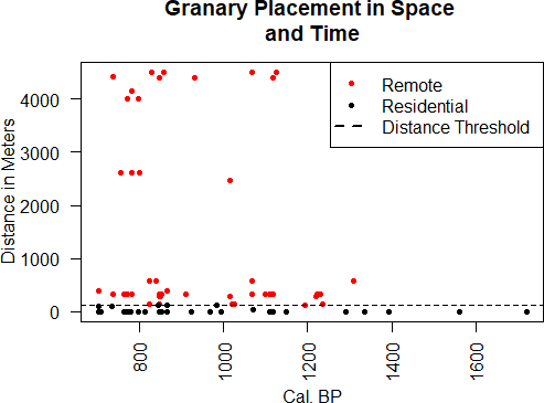
Figure 3 (above): Point plot of granary distribution in space and time. The distance threshold of 120.50 meters is also shown here. This threshold was the defining measurement determining whether a granary was remote or residential
Initial Distributions
Initial plots show how granaries are spatially and temporally related (Figure 3). A hashed line is also included and represents the maximum distance threshold of 120.50 meters. A majority of points are found above the threshold, indicating that a majority of the granaries sampled are remote. This is according to the maximum distance threshold; however, evidence from site recording forms also corresponds with this representation. This plot also showcases the distribution of granaries temporally, with points indicating increased use of storage after 1,400 calibrated years BP. This is the same case for distance with granaries over the maximum distance threshold, increasing in prevalence after 1,400 calibrated years BP.
Probability of Granary Remoteness
The final analysis of the project saw the calculation of a granary being remote based on its placement in time and space (Figure 4). This calculation saw that the probability that a granary is remote given its spatial location and temporal context saw an increased likelihood over time. The earliest sites saw relatively low to no probability of being remote. Then, around 1,550 BP, there is an increase in the probability of remote granaries occurring. The probability peaks at about 80% at 1,200 BP, then again at 800 BP. This trend indicates increased use of remote storage at later sites and decreased use at earlier sites. Further, this trend shows that defensive patterns shifted over time; earlier sites utilized the active defense of residential storage, and later sites employed passive defense through remote storage. Another note to make is that there was never a time of 100% probability of remote storage, indicating that both defense strategies might have been utilized simultaneously. However, the increase in likelihood indicates that the passive defense strategy did see adoption later, unlike active defense, which seems to be employed throughout the occupation of the region.
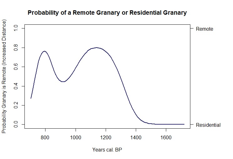
Figure 4. Modeled probability a granary is remote given its placement in time and space.
Discussion
Interpreting Results
Initial interpretations of the results indicate that the probability of remote storage strategies being utilized increases over time. However, understanding what drove this strategy to emerge is important. Agricultural subsistence first became prevalent in the GSENM around 2,000 years ago, prompting the utilization of complex food storage (Codding et al. 2022; Yaworsky 2021). This strategy ensured that prehistoric farming populations would have food surpluses for coming winters and to offset shortfalls from interannual harvest variation (Winterhalder et al. 2015). Interestingly, the conditions that made farming suitable in the GSENM and the populations of prehistoric farmers in the region both saw a considerable increase at roughly the same time as the probability of remote granaries occurring began increasing (Codding et al. 2022; Vernon et al. 2023; Yaworsky et al. 2023). Considering that regional population growth would likely lead to increases in resource theft and the territorial behaviors of prehistoric people of the area, it is probable that the passive defense via remote storage was a response to this (McCool & Yaworsky, 2017). Resource theft is a highly effective strategy, others do the work while the thief gains the rewards. Seen elsewhere in the region, prehistoric people of Utah typically employ a defensive strategy that favors a nonconfrontational solution. Passive defense through the placement of remote granaries is an incredibly costly strategy for prehistoric farmers. However, if paying this cost meant protecting food surplus in a nonconfrontational way, farmers in the area would likely use this strategy, leading to increases in remote storage as population grows. Additionally, the probability of a granary being remote decreases around 800 BP. While this is likely due to a lack of data in the model, this could also hint toward the eventual abandonment of agriculture in the region, which occurred around this time. This period saw declines in both the suitability of agriculture and population size (Codding et al. 2022). This indicates that the probability that remote granaries are occurring or being built appears to follow the decline in population and agricultural suitability in the area around 800 BP.
Defining Granary Type
Throughout the research presented here, distance was the key defining factor for determining granary type. However, defining granary type is typically much more complex than this. Factors such as accessibility, cost distance to location, viewshed, elevation, and overall visibility should be considered to truly define granary type. Distance to residential sites was used as the key factor in this preliminary study due to the weight of distance in determining granary context. Information on the distance to residency was also readily available and offered unique insight into the early observations of granaries in the area. Future models of granary variation could be completed without using distance to residency as the determining factor of granary type. Using distance as the determining factor raises issues with granaries that occur at exceptionally long distances from residential sites. This is due to a lack of residential sites found in relative proximity to these granaries. Granaries that occurred over distances of 3,500 meters likely had a residential site that was not observed during the archaeological fieldwork. This appears to be the biggest issue using distance as the only key factor. Granaries occurring at long distances are classified as remote in this study, potentially influencing the probability of remote granaries occurring over time. Using the previously mentioned methods to determine granary type could address these issues in future iterations of the study, especially when evidence of residential sites in reasonable proximity are not found.
Conclusion
Since the earliest archaeological fieldwork in the southwestern regions of Utah, observations about granary distributions have been presented. Often, researchers would remark on the variation in granary placement, curious about why some are found within long- term occupational settings while others are found in remote locations miles from the nearest residential sites. Shifts in defensive behavior offer an interesting answer to this variation. Two defensive strategies are associated with the two types of granaries presented within this project. Active defense of residential granaries and passive defense of remote granaries. However, it was unlikely that these defensive strategies emerged simultaneously. More reasonably, one of these strategies occurred first, and as agricultural suitability and population in the region increased, another strategy emerged in response to these changes. Resource theft is commonplace in agricultural societies, and given the defensive and territorial strategies of the regional populations in Utah, it is likely that the people within the GSENM sought to protect agricultural produce in a nonconfrontational way. A nonconfrontational territorial strategy aligns well with the passive defense strategy associated with remote storage. Using the probability that a granary is remote given its placement in time and space allows us to see how this passive defense strategy emerged. Using new applications of radiocarbon dating methods to find times of construction and use of granaries and then calculating the distance of granaries from residential sites, we can understand the temporal and spatial context of granaries presented in the study. Modeling this relationship shows that remote granary use increases around 1,400 BP and remains in use until about 800 BP. This indicates that there was a shift to passive defense around the 1,400 BP period. Providing an interesting insight into regional granary distributions, variations in granary placement are the results of shifts in defensive strategies, due to growths in the regional population as an outcome of the abundance of food brought on by increased agricultural suitability.
Acknowledgments
Thanks to Dr. Brian Codding for his wonderful assistance in mentoring this project. A special thanks also goes to Jerry Spangler and members of CPAA for completing the archaeological fieldwork that procured the samples for this project. Thanks to Ishmael Medina for guidance in the lab and Adrian Bell for guidance in statistical modeling. I also thank the Office of Undergraduate Research for funding this research. Finally, thank you to Callum Dingley and my other undergraduate friends who helped with peer reviewing and provided input on the research.
Bibliography
Barlow, R., & Phillips, K. L. (2010). Simple financial economic models of Fremont maize storage and an assessment of external threat. MPRA Paper. https://ideas.repec.org/p/pra/mprapa/23502.html
Codding, B. F., & Brewer, S. C. (2024). Regression with Archaeological Count Data. Advances in Archaeological Practice, 12(2), 163–172. https://doi.org/10.1017/aap.2024.7
Codding, B. F., Coltrain, J. B., Louderback, L., Vernon, K. B., Magargal, K. E., Yaworsky, P. M., Robinson, E., Brewer, S. C., & Spangler, J. D. (2022). Socioecological dynamics Structuring the spread of farming in the North American Basin-Plateau region. Environmental Archaeology, 27(4), 434–446. https://doi.org/10.1080/14614103.2021.1927480
ESRI. ArcGIS Pro Release [3.4.1] Redlands, CA: Environmental Systems Research Institute. (2025)
Gunnerson, J. H., Expedition, C., Claflin, W. H., & Emerson, R. (1969). The Fremont Culture: A Study in Culture Dynamics on the Northern Anasazi Frontier, including the Report of the Claflin-Emerson Expedition of the Peabody Museum. http://ci.nii.ac.jp/ncid/BB17378481
McCool, W. C., & Yaworsky, P. M. (2017). Fight or flight: An assessment of Fremont territoriality in Nine Mile Canyon, Utah. Quaternary International, 518, 111–121. https://doi.org/10.1016/j.quaint.2017.11.032
McFadden, D. A. (2016). Formative chronology and site distribution on the Grand Staircase-Escalante National Monument: A Research Reference.
Morgan, C. (2012). Modeling modes of hunter-gatherer food storage. American Antiquity, 77(4), 714-736.
R Core Team. (2025). R: A Language and Environment for Statistical Computing [Software].
R Foundation for Statistical Computing, Vienna Austria. https://www.R-project.org/.
Spangler, J. D., & Zweifel, M. K. (2021). Deep roots: A 10,000-year Indigenous History of the Grand Staircase-Escalante National Monument.
Spangler, J.D., M.K. Zweifel, I.D. Medina, W.C. McCool, M. Eisenberg, R.B. D’Andrea, & B.F. Codding (2024) Report on New Radiocarbon Dates from Granaries on Fiftymile Mountain, Kaiparowits Plateau, Grand Staircase-Escalante National Monument.
Report submitted to Bureau of Land Management. State Project No. U24C10209, DOI Permit No. 22UT82469, GSENM Assistance Agreement L22AS00071.
Vernon, K. B., Yaworsky, P. M., McCool, W., Spangler, J. D., Brewer, S., & Codding, B. F. (2024). The Fremont frontier: living at the margins of maize farming. American Antiquity, 89(3), 440–458. https://doi.org/10.1017/aaq.2024.22
Winterhalder, B., Puleston, C., & Ross, C. (2015). Production risk, inter-annual food storage by households and population-level consequences in seasonal prehistoric agrarian societies. Environmental Archaeology, 20(4), 337–348. https://doi.org/10.1179/1749631415y.0000000025
Yaworsky, P. M. (2021). Prehistoric Land Use in the Grand Staircase-Escalante National Monument and West Tavaputs Plateau, Utah [PhD Dissertation, University of Utah].
Yaworsky, P. M., Vernon, K. B., McCool, W. C., Hart, I. A., Spangler, J., & Codding, B. F. (2023). The Goldilocks Zone for maize agriculture and the settlement and abandonment of the West Tavaputs Plateau. Quaternary International, 689–690, 30– 42. https://doi.org/10.1016/j.quaint.2023.12.003
